NOTE: I wrote this opinion piece for WRAL.Com, the web site of WRAL-TV in Raleigh. WRAL.Com posted it yesterday.
* * *
An Appalachian Trail hiker was murdered earlier this month and a second hiker escaped death by playing dead after they were attacked in the middle of the night by a mentally disturbed man with a knife.
That murder was a tragedy but it was also a rarity, only the 11th murder on the A.T. in the last 45 years,according to the Appalachian Trail Conservancy, which manages and conserves the trail. During that period, beginning in 1974, tens of millions of people have hiked part of the trail and thousands have hiked all of it, from Springer Mountain, Georgia, to Mount Katahdin, Maine.
Thetrek.co, a hiker-oriented blog, has posted an interesting analysis comparing the murder rate for the United States as a whole to the murder rate on the trail and concluded that the U.S. murder rate is more than 800 times higher.
This season about 3,000 hikers are trying to walk all 2,192 miles of the A.T., through 14 states, and they have worries. But what they worry about may surprise you. Backpackers are a lot more concerned about ticks and the diseases they carry, including Lyme disease, than they are about being assaulted or killed. Or mauled by a bear or bitten by a rattlesnake.
Their concern is well founded.
“The greatest risk to your health and safety while hiking the Appalachian Trail is contracting a tick-borne disease,” the Conservancy says.
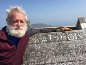
Lucky at Mt. Katahdin in Maine, July 14, 2015
I thru-hiked the A.T. in 2015 and the main concerns of hikers I met, after ticks, were:
—Injury. There are so many ways to trip and fall – you encounter a lot of ice, snow, mud, roots, rocks– and, just like that, your hike could be over.
—Illness. Nausea, vomiting and diarrhea from drinking bad water or from failing to wash or sanitize your hands. Hikers almost always filter the water they drink and they don’t shake hands, they bump fists because no one wants the other person’s germs.
—Failure. Three fourths of the thru-hikers don’t finish, according to the Conservancy. On average it takes almost six months and, every day, hikers are tired or wet or cold or hungry or hurt and on really, really bad days, they’re all five things at the same time.
The hiking community is not like the communities where you and I live, it’s more like family. I just returned last week from a three and a half day, 60-mile section hike of the A.T. in Virginia. I was hiking south so my friends and I encountered scores of hikers headed for Maine and almost all of them, strangers, greeted us. Some wanted to stop and talk.
Temper
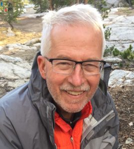
Hikers introduce themselves when they arrive at a shelter, three-sided huts, usually with a privy and a spring nearby. Most have trail names and that are easy to remember: “Iceman” carried ice to an injured girl and she named him; “Temper” had worked in a candy factory where she tempered chocolate; “Between” was 17 years old, between high school and college. My trail name is “Lucky” because I was fortunate to have the health to attempt a thru-hike and a wife who said Yes.
Most thru-hikers I met, including women, began their hikes alone. But after the first day or two, they are not alone – they are part of the hiker community that looks out for one another. They also take precautions:
– A few hikers regularly “stealth camp” in the woods. Almost everyone is forced to occasionally but, mostly, hikers stay together at night in or near one of about 250 shelters along the trail. A lot of them won’t stay at a shelter or camp close to a road – they’re concerned about town people who might park at the trail head and come looking for trouble.
–When they sense danger –another hiker who is acting strangely – they will pack up and move on. I’ve done that twice.
–Some carry pepper spray for bears. Or men.
–They warn other hikers they meet on the trail, or they leave warnings in shelter log books, about bears near a shelter or, maybe, a snake in the shelter. Or another hiker who has set off their alarm bell.
–Women usually adopt a gender-neutral trail name, like Eddy or Red Feather, so when they sign a shelter log book their sex is not obvious.
I don’t carry a pistol nor have I ever seen or heard about another hiker who was armed. I think they would be ostracized. Other hikers would fear them and, literally, walk away. And there’s another good reason for leaving your pistol at home – a loaded Glock pistol weighs almost 30 ounces. And, in case you don’t know, the three most important things about backpacking are pack weight, pack weight, and pack weight.
I’ve now hiked the John Muir Trail and it may be the most beautiful trail in America. Challenging too, in places. But it was not, as I said in an earlier post, my hike of a lifetime.
What was I thinking!
Am I glad I hiked the JMT with Iceman Aug. 6-21?
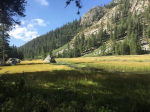
Because vegetation in the meadows is so fragile camping is not allowed there.
Yes.
Would I like to hike it again?
Let me come back to that in a few minutes.
* * *
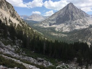
The JMT, named for John Muir, “Father Of Our National Park System,” begins at the Happy Isles trailhead in California’s Yosemite Valley and goes 210.4 miles south to the summit of Mt. Whitley, the tallest mountain in the lower 48 states at 14,508 feet. I got my first look at the JMT in a documentary, “A Mile, A Mile And A Half,”* after I finished hiking the Appalachian Trail. I immediately put it on my hiking wish list. Take a look at this 2 minute, 34 second trailer and you’ll see why.
It’s hard to compare the John Muir Trail to the A.T., my hike of a lifetime — they are so different. The A.T. starts on Springer Mountain, Georgia, and goes through the Appalachian Mountains 2,189.2 miles to Mount Katahdin in Maine. The A.T. is 10 times longer but the JMT is 10 times more beautiful, with dozens of lakes with water so clear you can see fish swimming on the bottom; lush green meadows; and snow on the mountains in August. Even so, the AT will always be my frame of reference through which I see, and judge, other trails.
* * *
So many people want to hike the JMT the government has restricted access — you have to have a permit. At some JMT trailheads I’m told you can get a permit just by being the first to sign up. But the hike we wanted required us to win the permit lottery or, if we didn’t win, show up and stand in line for however long it took to get a “walk up” permit.
“Iceman,” AKA Dave Martin
Iceman and I and two friends, Nine! and Viking, entered the lottery day after day last spring, 42 consecutive days — and lost.
But Iceman, who is 66, would not give up. He decided to fly to Los Angeles, and then on to Mammoth Lakes, California. From there he would ride a bus an hour and 15 minutes to Tuolumne Meadows, stand in line, and get one of the 10 walk-up permits handed out each day. I decided to join him.
Getting on the JMT near Tuolumne Meadows, instead of Happy Isles, forced us to skip the first 20 miles or so of the JMT. But what choice did we have? They don’t give out walk-up permits at Happy Isles and, as it turned out, it wouldn’t have mattered. When Iceman and I arrived at Tuolumne Meadows on Aug. 5 Happy Isles was closed due to heavy smoke from a nearby wild fire. Permits of hikers who had won the lottery and were scheduled to begin their hike there were canceled.
So how long did Iceman have to stand in line?
He got permits for both of us the morning we arrived, easy as pie. There was smoke in the air at Tuolumne Meadows too and, apparently, that caused a lot people to delay or cancel their hike.
***
I met Iceman, who is from Lancaster, Pennsylvania, on the A.T. – he was a trail angel who helped me on several occasions. I had never hiked with him but I knew he had hiked all of the A.T., section by section, so I knew he could do what had to be done. He’s a good one, a strong hiker who never complains about anything.
The JMT was, for me at least, a difficult hike.
I don’t know if it was all that up
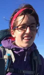
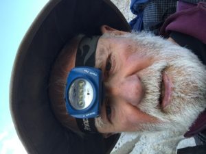
“Lucky,” AKA Pat Stith
and down, we averaged climbing, or descending, a total of a mile a day; the altitude, more than a third of the trail is above 10,000 feet; my age, I’m 76; or the lack of enough good food, I lost almost a pound a day for 16 days. Maybe I just wasn’t in good enough shape. Just before going I had hiked almost 100 miles around my neighborhood, carrying a full pack, but the altitude in Knightdale, North Carolina, is 315 feet and, compared to the JMT, my neighborhood is as flat as a kitchen table. Maybe it was all of those things because, for the first 10 days, I was pretty much worn out at the end of each day.
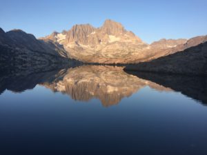
We camped one night at Garnet Lake.
My impressions of the hike:
***First and foremost, I repeat, the JMT is beautiful. Words don’t do it justice, or pictures for that matter.
***The JMT goes through mountain country, real mountains. The valleys we hiked through were 1,500 feet higher than the highest point on the A.T., North Carolina’s Clingmans Dome. And, of course, the JMT ends on Mt. Whitney, which is more than twice as high as Clingmans Dome.
***The Sierra Nevada mountain range, through which the JMT goes, is a wilderness. On the JMT you cross no roads, you walk under no power lines, you hear no traffic and you see no towns in the valleys, not even an isolated cabin.
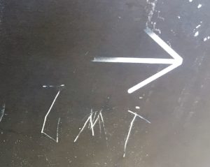
At one trail intersection someone scratched on the back of another sign, “JMT” beneath an arrow pointing to the right.
***The JMT is unmarked, there are no blazes, nothing to guide you. There is some signage at trail crossings but almost never do you see a sign that says, in effect, “JMT, that-a-way.” One of the rangers told me the trail wasn’t marked because the powers that be want the hike to be as much a “wilderness experience” as possible. I asked why they don’t also do away with signs at trail intersections and he said they were thinking about that.
You know what’s funny? To promote a “wilderness experience” the JMT boys have forced backpackers to carry a GPS and rely on satellites. We would have been lost, literally, without one.
You know what else is funny?
The A.T. is marked with thousands of white blazes and crisscrossed by roads and power lines. At night you can often see the lights of nearby towns. Sometimes you can hear trains and highway traffic. The A.T runs through or close to some of the most heavily populated areas in the nation — at one point you can see New York City in the distance. But in one way it’s much more like a wilderness hike than the JMT.
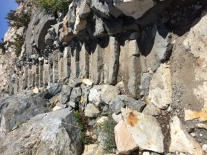
It wasn’t all like this, by any means. But they’ve built a lot of steps on the JMT.
On the JMT the trail goes up and down some pretty steep mountains but there is no rebar sticking out of boulders, like you see on the A.T., and no need for any. Instead, the JMT has thousands of rock steps, sometimes where no steps are needed. The A.T. is not that way. Yes, it has steps, too, but not many compared to the JMT. On the A.T., especially up North, hikers often have to climb or descend near vertical sections the best way they can.
Question you may have wanted to ask:
Q. How far did you hike, how many miles per day did you average?
Iceman and I hike 200 miles, including the trail down Mt. Whitney back to civilization, in 16 days, and 45 minutes.** We averaged 12.5 miles a day. That’s the distance we had planned to hike each day but we had thought that was a conservative number. We figured we could average 14 or 15 miles if push came to shove. I think Iceman could have; I’m not so sure about myself.
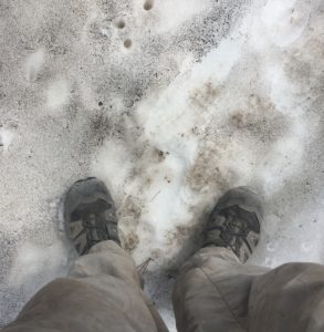
I did so hike in snow, about two steps.
Q. The documentary “A Mile, A Mile And A Half” was filmed several years ago in late July and they encountered a lot of snow. Did you hike through snow?
No. We saw a lot snow, above us sometimes, below us sometimes. I actually walked through a tiny bit, just to say I had, but no.
Q. Was it cold?
At night, yes, in the high 30’s or low 40’s is my guess. And in the high 80’s in the afternoons, at least that’s what it felt like. The passes were cooler and the top of Mt. Whitney was downright chilly when we arrived late in the morning.
Q. Were you bothered by smoke from the wild fires?
I was, a little, for the first couple of days. But as we hiked south, away from the fires, smoke was not a problem.
Q. What was your biggest surprise?
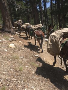
Mule trains force hikers to watch their step.
There’s a lot of manure on the JMT, left there by mule trains carrying supplies and equipment to folks who can’t, or don’t want to, carry it themselves.
Q. Did you encounter bad weather?
Yes, hail, one afternoon as we came down a mountain. As we descended into warmer air, the hail turned into a cold, driving rain. I didn’t put on rain gear until after I was already soaked, a mistake. It rained pretty hard one other night after we were in our tents. Other than that the weather was gorgeous.
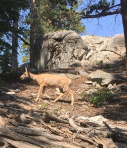
Q. Did you see any bears, or other wildlife?
Deer ignored us.
We saw a number of deer, who ignored us until we got close, and a lot of marmots –which I had never seen before. We were warned about bears and were required to carry our food in what’s called a “bear barrel,” but we didn’t see a bear.
Q. So, would you like to hike it again?
Yes, but no.
Knowing what I know now I would like another crack at the JMT. But I’m running out of time and I’d rather go canoeing in Canada, portaging from lake to lake to lake. Wouldn’t that be a hoot! GRRRR and I are talking about doing that next year, in Algonquin Park.
* “A mile, a mile and a half” is an expression often used by backpackers to describe the distance to anywhere. When two hikers meet each other on the A.T. one might ask, “How far is it to the next shelter.” The other might reply, “A mile, mile and a half.”
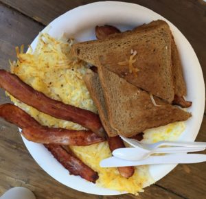
Our first real meal in two weeks. Oh, yes, we cleaned our plates.
**When Iceman and I woke up on Day 17 we were only 2.7 miles from the first real food we had eaten in two weeks, since we had resupplied at Reds Meadow. We were hungry —motivated — and the trail was all downhill. We did did it in 45 minutes, an averaged 3.6 mph. Ask anybody who has ever carried a backpack — that’s rolling.
Coming Monday: Three Things Mountain People Don’t Like