Two years ago today I was on the second day of my Appalachian Trail hike from Georgia to Maine. It could have been my last.
Day One was cold, 8 degrees, when I got out of Brother Dave’s car, met my kinsman, Cary Tucker, who hiked with me that first morning, and climbed Springer Mountain, the A.T.’s southern terminus.
Day Two was colder. An ice storm was rolling in and there was a lot of wind. Off and on all day and into the night, it sleeted.
I had planned to hike from the Gooch Mountain shelter, where I spent my first night in a tent, to Neel Gap, 15.9 miles, to a hostel there called Mountain Crossings. But Blood Mountain, which I had to cross at the end of the day, was giving me pause. I had hiked it before with one of my grandsons, Christian Stith, and I knew what it was like. At 4,461 feet, it is the highest point on the A.T. in Georgia, and it’s steep, especially at the top on the north side. It would be icy, too. So I decided to spend the night at Woods Hole shelter, 3.5 miles short of my goal.
But when I got to Woods Hole, late that afternoon, I didn’t stay. I should have, but I didn’t. I decided to climb Blood Mountain, only another 1.1 mile from Woods Hole, and stay at the shelter on top of the mountain.
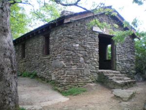
But when I got to the top of the mountain I didn’t like what I saw. The shelter, one of the few made of stone, was dark, cold, and, like Woods Hole, empty. At the bottom of the mountain, only 2.4 miles away at Neel Gap, there was a hostel where I could get hot food and a shower. There would be people there too, probably, other thru-hikers. It was 6 o’clock, almost dark, but I decided to keep going – I could be there in an hour or so. It was a decision I would soon regret.
The northbound descent from Blood Mountain starts with a series of mostly flat boulders slanted downhill, strung together by short pieces of trail. On this night, those boulders were covered with ice. I couldn’t stay on my feet, I had to sit down and slide. Twice I careened out of control, bouncing off whatever got in the way, banging up one of my knees in the process.
White blazes marking the trail were painted on the rocks but, covered with ice and snow, I couldn’t see them. Or, maybe, zipping by like a runaway train, I just didn’t see them. When I finally came to a stop at the bottom I couldn’t find the trail and, believe you me, it was not for lack of trying.
My situation reminded me of an old adage I picked up from one of my nephews, Chuck Stith: “If you’re gonna be dumb, you gotta be tough.”
There was no going back to the shelter at the top of the mountain, the boulders were way too slick to climb. My only choice was to bushwhack down the mountain, through the woods, until I found the A.T. I put my cap light in my mouth — normally I would have clipped it to a baseball cap but I was wearing a toboggan — to light the way, to free my hands so I could use my hiking poles, and took off.
Finally, after full dark, I found a trail. Thank goodness!
I turned to my left and hiked on down the mountain for half an hour until I saw a blue blaze. I was not on the A.T., the A.T. is marked with white blazes. I had stumbled on to the Freeman Trail, which intersects the A.T. somewhere on the north slope of Blood Mountain. But where? Should I keep going or turn back?
I turned back, hiked to the place where I had come out of the woods, and kept on going, looking for the A.T. It was 8:30 p.m. when I decided to call it a day. I had been hiking more than 12 hours on the two pop tarts I had eaten for breakfast. I had skipped lunch and, of course, supper.
Now I had to find a spot on the trail wide enough and flat enough to pitch my tent. And I did, finally, a four-by-eight-foot sheet of ice. Not flat, but flat enough. I took my backpack off and, at that moment, my cap light battery died. I was in total darkness. It was still sleeting.
Continued tomorrow.